Key Takeaways
- TrailPrint3D is an innovative tool that converts GPS data into 3D printable terrain models
- The app allows users to create detailed models of their outdoor adventures, such as hiking trails or bike routes
- The models can be printed using a 3D printer, providing a unique and tangible way to relive memories
- TrailPrint3D supports various file formats, including STL and OBJ, making it compatible with most 3D printing software
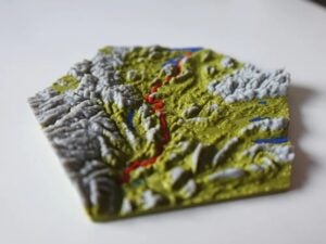
Introduction to TrailPrint3D
TrailPrint3D is a revolutionary app that enables users to transform their GPS data into 3D printable terrain models. This innovative tool is perfect for outdoor enthusiasts who want to create a lasting memento of their adventures. With TrailPrint3D, users can generate highly detailed models of their favorite trails, complete with precise elevation data and terrain features.
How TrailPrint3D Works
The app uses GPS data to create a 3D model of the terrain, which can then be exported in various file formats, including STL and OBJ. This allows users to print their models using a 3D printer, creating a tangible and detailed representation of their outdoor adventure. TrailPrint3D supports a range of GPS devices and file formats, making it easy to import and process data from various sources.
Comparison of 3D Printing Methods
| Method | Resolution | Material | Cost |
|---|---|---|---|
| Fused Deposition Modeling (FDM) | 100-200 microns | PLA, ABS | $200-$500 |
| Stereolithography (SLA) | 10-50 microns | Resin | $500-$1,000 |
| Selective Laser Sintering (SLS) | 50-100 microns | Nylon, Aluminum | $1,000-$2,000 |
Benefits of TrailPrint3D
TrailPrint3D offers a unique way to relive outdoor adventures, providing a detailed and accurate model of the terrain. The app is also a great tool for planning and preparing for future adventures, allowing users to visualize the terrain and plan their route accordingly. With its high level of detail and accuracy, TrailPrint3D is an essential tool for outdoor enthusiasts, educators, and researchers.
Bottom Line
TrailPrint3D is a groundbreaking app that enables users to convert GPS data into 3D printable terrain models. With its high level of detail and accuracy, this innovative tool is perfect for outdoor enthusiasts, educators, and researchers. Whether you're looking to relive a memorable adventure or plan a new one, TrailPrint3D is an essential tool that provides a unique and tangible way to experience the great outdoors. With its compatibility with various 3D printing methods and file formats, TrailPrint3D is an excellent choice for anyone looking to create detailed and accurate terrain models.